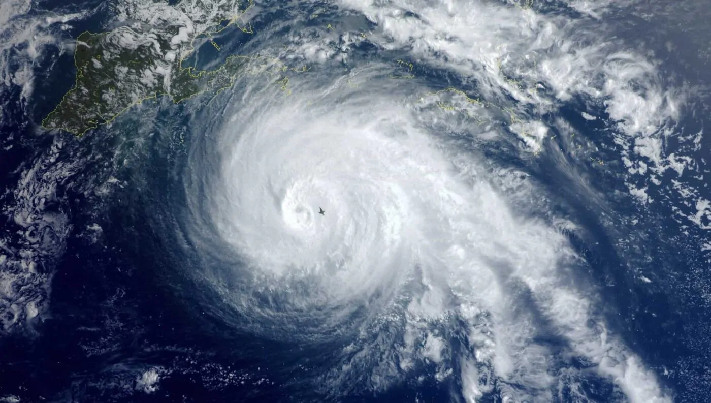
Tropical Storm Erin has emerged as the fifth named storm of the 2025 Atlantic hurricane season, currently gaining strength in the open Atlantic Ocean and poised to become the season’s first hurricane by Friday, according to the National Hurricane Center (NHC). This developing weather system showcases classic patterns of rapid intensification, hurricane formation, Atlantic basin activity, and tropical cyclone development that meteorologists closely monitor during peak hurricane season. The storm’s current position at latitude 16.3° North and longitude 48.2° West places it approximately 990 miles east of the northern Leeward Islands, with maximum sustained winds reaching 50 mph and higher gusts as of Thursday morning. Hurricane Hunters are preparing to investigate the strengthening system, while computer models and forecast tracking indicate potential development into a major Category 3 hurricane with winds reaching 125 mph, though current projections suggest the storm path will likely remain north of populated Caribbean islands and away from immediate coastal threats to Florida and the southeastern United States.
Latest status from the National Hurricane Center
As of Thursday 14 August 2025 0900 UTC, the National Hurricane Center lists the center of Erin near 16.3N 48.2W, moving west at about 15 kt with maximum sustained winds near tropical storm strength and minimum central pressure around 1002 mb. Forecast guidance indicates strengthening, with hurricane status possible on Friday. Official sources
- NHC Atlantic Tropical Weather Outlook
https://www.nhc.noaa.gov/text/refresh/MIATWOAT+shtml/141139_MIATWOAT.shtml - NHC Forecast Advisory text for Erin
https://www.nhc.noaa.gov/text/refresh/MIATCMAT5+shtml/140845.shtml
Quick status table:
| Item | Current detail | Source |
|---|---|---|
| Location | 16.3N 48.2W | NHC Forecast Advisory 0900 UTC Aug 14 2025 |
| Movement | West near 15 kt | NHC |
| Minimum pressure | 1002 mb | NHC |
| Intensity | Tropical Storm | NHC |
| Watches or warnings | None for land areas at the time of the advisory | NHC |
Note: Values update frequently. Always check the latest NHC advisory for changes.
Track outlook and key hazards
- Model guidance and NHC forecasts keep Erin over the open Atlantic in the near term, generally west to west northwest.
- The NHC notes conditions favorable for strengthening, with warmer sea surface temperatures and pockets of lower vertical wind shear ahead.
- Peripheral impacts such as swells, rip currents, and intermittent squally showers could affect parts of the northern Leeward Islands in the coming days even if the center remains well offshore.
- No coastal watches or warnings were in effect at the time of writing. Monitor NHC updates for any changes.
Trusted Preparedness Resources
- Ready.gov Hurricanes
https://www.ready.gov/hurricanes - FEMA Ready resources
https://www.ready.gov/plan
Frequently asked questions
Q: Is Erin expected to reach hurricane strength?
A: The NHC indicates hurricane intensity is possible on Friday based on current trends. Always defer to the latest advisory for status updates.
NHC overview and advisory links
https://www.nhc.noaa.gov/text/refresh/MIATWOAT+shtml/141139_MIATWOAT.shtml
https://www.nhc.noaa.gov/text/refresh/MIATCMAT5+shtml/140845.shtml
Q: Are there any watches or warnings?
A: At the time of the 0900 UTC advisory, none were in effect for land areas. This can change if the track or wind field evolves.
Q: Should I pay attention if I am not in the forecast cone?
A: Yes. Swells and rip currents can extend far from the center. Marine and beach hazards often precede the closest approach by a day or more.
What boaters should note this week
- Check daily marine forecasts and the wind wave outlook along your route.
- Verify engine, bilge pumps, radios, and EPIRB readiness.
- If transiting east of the Lesser Antilles, evaluate alternate windows to avoid squalls and building seas.
Signals to watch in the next 48 to 72 hours
- A faster than expected rate of intensification, which can expand wind radii.
- Subtle track wobble to the west northwest that could shift swell exposure.
- Changes in shear or dry air entrainment, which can slow strengthening.
- New NHC Key Messages updates that highlight emerging risks.
What to do if the Forecast Changes
- Prioritize official information from the NHC and your national meteorological service.
- Avoid acting on single model runs or social media speculation.
- If watches are issued, secure outdoor items, fuel vehicles, and plan for potential power interruptions.
Historical Context and Storm Comparisons
Previous Category 3 hurricanes in similar Atlantic locations have demonstrated the potential for rapid intensification when environmental conditions align favorably, providing meteorologists with historical analogs for Erin’s development.
Climatological data suggests storms forming in Erin’s general location during mid-August often achieve major hurricane status, though most remain over open ocean areas without threatening populated coastlines.
Seasonal comparisons indicate 2025 Atlantic activity remains within normal ranges, with Erin’s development representing typical peak season formation patterns observed in previous years.
Media Snapshots and Context
Reputable outlets echo the NHC trend of likely strengthening into a hurricane, with potential risks from heavy rain, high surf, and tropical storm force winds near the northern Leewards if the system edges closer. For situational awareness, regional stations often carry timely clips while pointing back to NHC for official guidance. Example
- WESH Orlando report on expected hurricane upgrade
https://www.wesh.com/article/tropical-storm-erin-2025-florida/65778086
Essential official links:
- NHC Atlantic main page
https://www.nhc.noaa.gov - Erin Forecast Advisory text
https://www.nhc.noaa.gov/text/refresh/MIATCMAT5+shtml/140845.shtml - Atlantic Tropical Weather Outlook
https://www.nhc.noaa.gov/text/refresh/MIATWOAT+shtml/141139_MIATWOAT.shtml - Preparedness resources at Ready.gov
https://www.ready.gov/hurricanes
Data snapshot table for quick reference
| Time window | Expected status | Notable risks |
|---|---|---|
| Next 12 to 24 hours | Strengthening tropical storm | Building swells and rip currents for northern Leewards |
| 24 to 48 hours | Possible hurricane | Higher seas, stronger squalls on the periphery |
| 48 to 72 hours | Hurricane if conditions persist | Track shifts could alter swell exposure and timing |
Note: This table summarizes NHC trends noted in the latest advisory and will change as new advisories are issued.